
According to a new study from RAISG, in just five years, the Amazon could lose almost half of what it lost in the past two decades.

According to a new study from RAISG, in just five years, the Amazon could lose almost half of what it lost in the past two decades.
To understand the reasons for such a bleak future, they analyzed the deforestation rates of recent years, identifying the main threats in the present and pointing to measures needed to reverse this process.
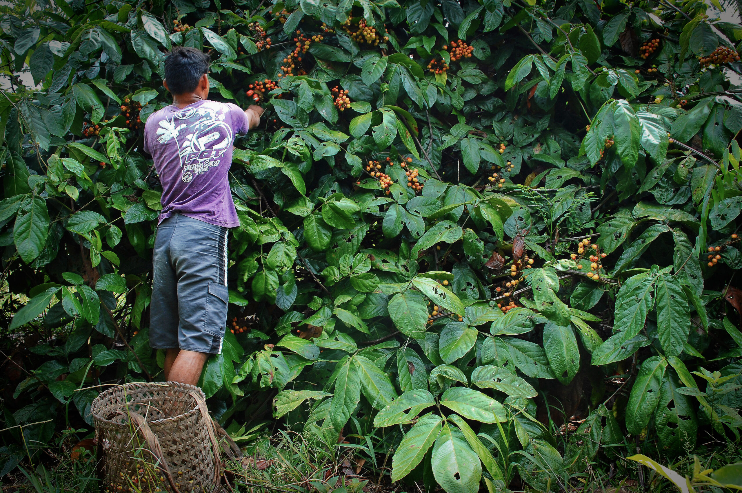
Photo: Vinícius Mendonça/Ibama
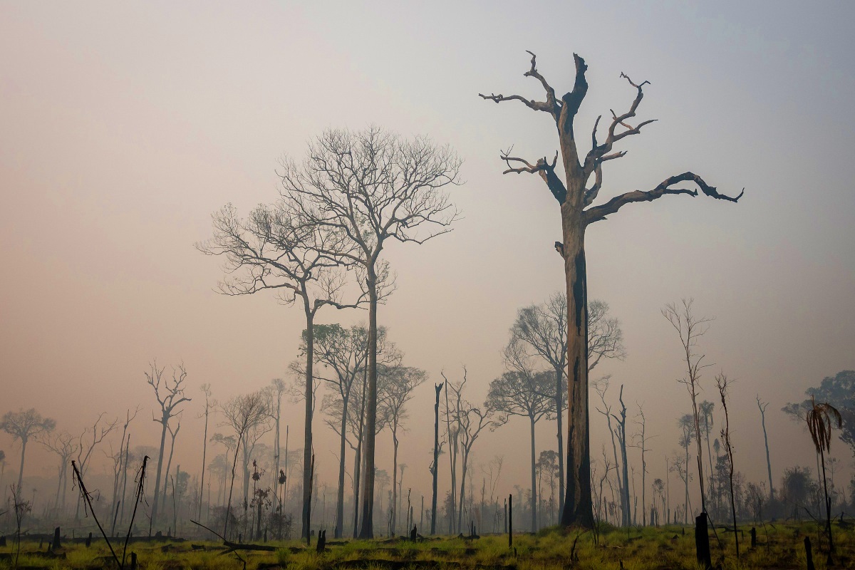
In a span of five years, the Amazon may have lost up to 23.7 million hectares of forest, an area almost as large as the entire United Kingdom. These are the findings of a study published by the Amazon Network of Georeferenced Socio-Environmental Information (RAISG), pointing to three possible scenarios of deforestation from 2021 to 2025 – optimistic, moderate and pessimistic. According to the pessimistic scenario, in just five years, the largest tropical forest on earth will lose half of what it lost in the last 20 years (54.2 million hectares).
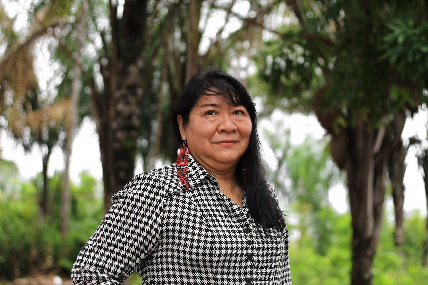
“Deforestation mainly impacts climatic stability, as well as the quality and quantity of water,” says Tina Oliveira-Miranda, one of the authors of the study and coordinator of Territorial Information Systems of Wataniba, a civil society organization based in Venezuela. “It is strongly connected to such processes as forest fires. This implies an increase in greenhouse gas emissions and, obviously, ramps up the repercussions in terms of the climate.”
The study «Deforestación en la Amazonía al 2025» [“Deforestation in the Amazon by 2025”] covers the area denominated by RAISG as the “Amazon Region”, which spans nine countries and approximately 850 million hectares (8.5 million km2), including the entire Amazon River Basin and sections of transition into other biomes, such as the Andes, the Cerrado, the Chaco and the Pantanal.
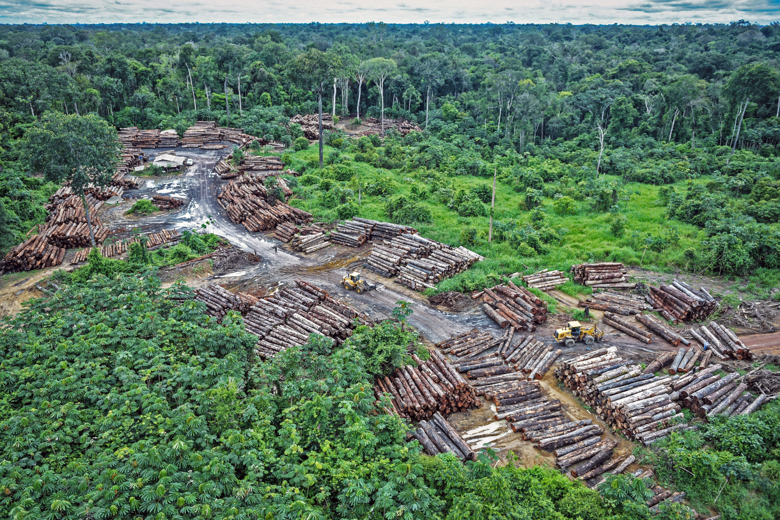
The results show that factors of change in use of the land such as livestock farming, mining and the expansion of the road infrastructure continue to put tremendous strain on the forest and its peoples. Activities like gold mining, coca farming and drug and weapons trafficking are aggravating the situation, putting those who protect the forest at risk.
With specialized methodologies and algorithms processed on the Google Earth Engine platform, the study detected a total of 55 million hectares of forest with accessibility and territorial conditions that make it especially vulnerable to destruction, in other words, where the probability of deforestation is higher than zero. This surface area is equal to the sum of all the deforestation that took place in the Amazon from 2001 to 2020, the two-decade period analyzed by 20 specialists from six Amazonian countries who contributed to the study.
54.2 million hectares lost in 20 years
The Amazon is home to 30% of the planet’s biodiversity, according to the International Union for Conservation of Nature (IUCN). New plant and animal species are being discovered all the time.
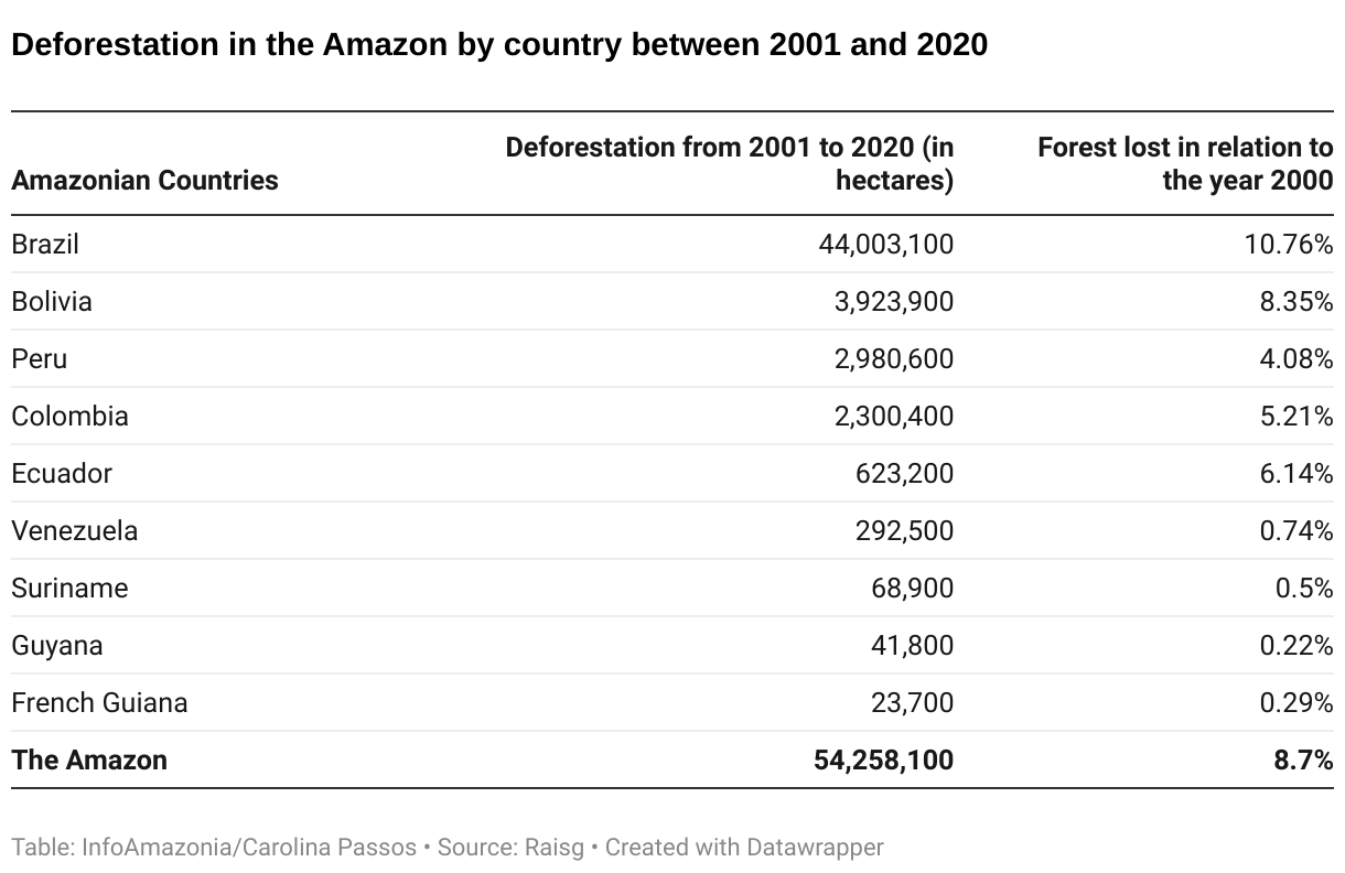
However, the accelerated destruction of the biome can lead to the extinction of species that have yet to be discovered or studied by science. Considering the data collected for the RAISG study, it is quite likely that this has already happened. Between 2001 and 2020, the Amazon lost over 54.2 million hectares, or almost 9% of its forests, an area the size of France. The Brazilian Amazon, – home to 62% of the Amazon’s territory – was most affected, followed by Bolivia, Peru and Colombia.
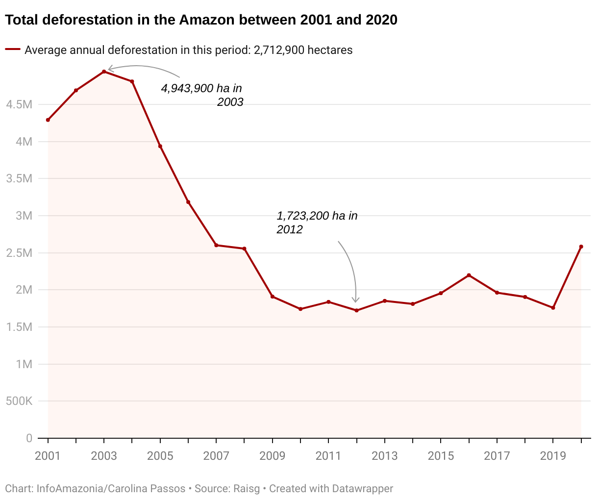
he year with the highest percentage was 2003, reaching almost 5 million hectares of cleared forest. Policies to combat the devastation in Brazil caused regional rates to fall in subsequent years, but, from 2019 on, there is a new upward curve in the deforestation rates, driven in large part by the Brazilian government and policies meant to weaken the agencies responsible for environmental oversight.
In 2020, the last year included in the study, the total deforested area once again nears the annual average of the previous two decades: 2.7 million hectares.
Drivers of Deforestation
According to the atlas “Amazonia Under Pressure”, published by RAISG in 2020, 66% of the Amazon is subjected to some sort of pressure that generates deforestation or degradation. The most important activity is livestock farming, which accounted for 84% of the devastation in the two first decades of this century.
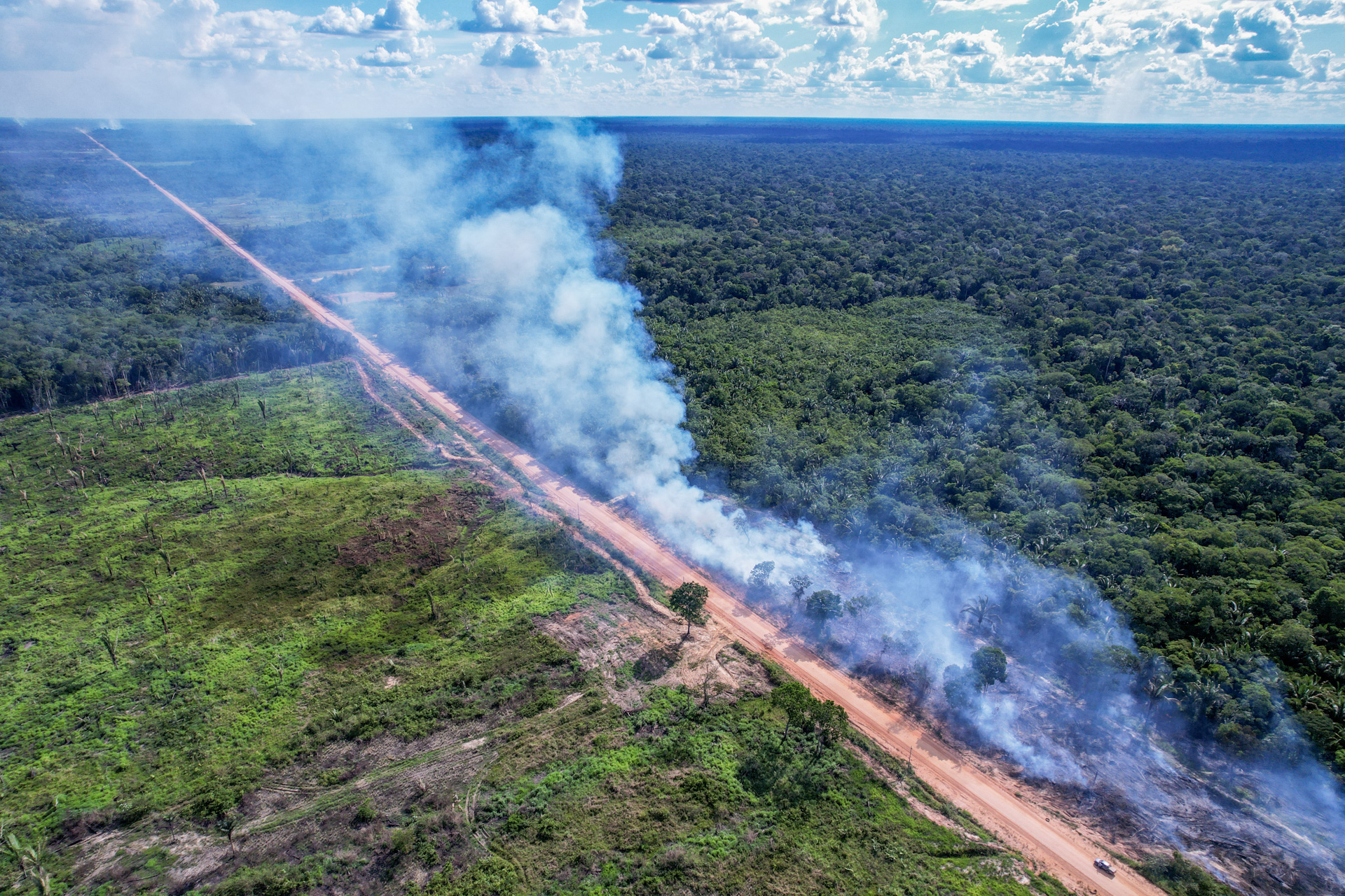
RAISG highlights the crucial role played by infrastructure in driving deforestation: It is no coincidence that the loss of vegetation is directly related to the various means of access that cut into the forest, whether they be roads, rivers or landing strips.
“Infrastructure, especially road infrastructure, will continue to be one of the great drivers of deforestation,” says Pablo Moutinho, a researcher at the Institute of Environmental Research of the Amazon (IPAM, by the original Portuguese acronym). “If you take the history of deforestation, over 70% of the forests cleared were located within a stretch of 50 kilometers on each side of the roads, mainly paved roadways.” RAISG estimates that over half of the Amazon is impacted in one way or another by the region’s road infrastructure. In addition to stimulating the disorderly occupation of the territory, putting even more pressure on Indigenous Territories (ITs) and Protected Natural Areas (PNAs), the roads favor the outflow of illegal merchandise such as lumber and minerals.
Infrastructure, especially road infrastructure, will continue to be one of the great drivers of deforestation
Paulo Moutinho, researcher at IPAM
Logging and illicit coca plantations are other activities that proliferate in the region, supported by demand from international markets. Most of the coca plantations end up in the hands of the drug trade for the production of cocaine. The illegal activity is associated with a network of clandestine roads used by criminal organizations.
Paulo Moutinho warns that emerging forces in the Amazon, essentially linked to criminality, could turbo-charge the deforestation taxes. “If we aren’t able to revert this new dynamic of illegal land occupation in the Amazon, which is associated with organized crime and related to drug and gun trafficking and illegal gold mining, we will most certainly see rates increase in coming years.”
Peru and Brazil: The Risk Posed by Highways
“Today I have just left my community,” said Herlin Odicio in an interview with InfoAmazonia. The president of the Federation of Kakataibo Indigenous Communities (FENACOKA, by the original Spanish acronym) in Peru left his territory in July of last year after receiving death threats.
Illegal economic activities such as logging, coca farming, drug trafficking and irregular land occupation – with land titles irresponsibly attributed to the settlers by local authorities – make this territory in the western reaches of the Amazon, nearing the Andes, particularly dangerous. Between April of 2020 and July of 2021, four individuals of the Kakataibo and three of the Ashaninka indigenous peoples were killed in conflicts in their territories.
The Reserva Indígena Kakataibo Norte y Sur [“KakataiboNorth and SouthIndigenous Reserve”] was created in July of 2021, with an area of almost 149,000 hectares, as an important landmark and to attend to the grievances of indigenous organizations. “The creation of the reserve helps to guarantee the lives of my brothers and sisters who live in the forest and to stop the invasions and threats to our ancestral territories,” Herlin said.
The creation of the reserve helps to guarantee the lives of my brothers and sisters who live in the forest and to stop the invasions and threats to our ancestral territories.
Herlin Odicio, president of FENACOKA
The situation of the Kakataibo people is aggravated by the fact that the only road connecting Pucallpa, the second largest city in the Peruvian Amazon, to the rest of the country cuts through their territory. This facilitates access to the region on the part of criminal elements as well as ever increasing cattle-raising operations. There is a great risk that both will further intensify in the event that the construction of the highway connecting Pucallpa to Cruzeiro do Sul, in the Brazilian state of Acre, is made viable.
On the Brazilian side, not far from there, another frontier of deforestation is quickly gaining ground: Amacro, whose name is a combination of the abbreviations for three Brazilian states (Amazonas, Acre and Rondônia). Given the large amount of protected areas, 142 total, the region was officially christened the Abunã-Madeira Sustainable Development Zone by the Brazilian government in 2021.
In practice, however, there is nothing sustainable about the activities taking place there. The region is directly impacted by Interstate BR-319, which connects Porto Velho, Rondônia to Manaus, Amazonas. With its intermediate section currently covered in mud, the road caught the attention of Jair Bolsonaro, who made the promise to pave it while campaigning for president in 2018. In fact, in July of 2022, the Instituto Brasileiro do Meio Ambiente e dos Recursos Naturais Renováveis (Ibama) issued a preliminary license for the interstate’s reconstruction. Human settlements already proliferate along its margins.
Between 2001 and 2020, according to RAISG, the Abunã-Madeira Sustainable Development Zone/AMACRO lost 4.5 million hectares of forest, at a rate of 26 soccer fields per hour. According to a recent report from MapBiomas published in 2021, the region saw an increase of nearly 29% in deforestation compared with the previous year.
In 2020, about 76% of the deforestation in the Amazon took place in Brazil. That same year, 32% of the illegal deforestation took place within Undesignated Public Forests (UPFs), forest areas that belong to state or federal governments and are yet to have their use decreed, which currently account for almost 57 million hectares.
Over half of the deforestation that took place before 2020 in UPFs were in areas listed in the Rural Environmental Registry (CAR, by the original Portuguese acronym), an important device for regulating rural properties, but which is largely constituted of irregular registers that have not been verified or validated.
“What we have today is a ticking time bomb– that is, the number of fraudulent registers declared in Undesignated Public Forests and in Indigenous Territories has grown alarmingly in the last five or six years,” Moutinho says. “Based on the scenario that is currently in place, mainly in the Brazilian Amazon, it is possible that any projection (of deforestation) for 2025 is underestimated, and by a lot.”
Colombia: Out With the Guerrillas, In With the Cattle
Covering an area of 200,000 in the north of the Colombian Amazon, Tinigua National Natural Park is a point of contact between the Amazonian and Andean ecosystems, part of a mosaic formed by other adjacent national parks. The southern part of the reserve, where the tropical forest predominates, has been most affected by the landscape’s fragmentation and the advance of pastures. The illegal appropriation of land, illicit farming and the clearing of roadways are also driving deforestation in the region.
“When the FARC was in power, there was territorial control limiting the entrance of actors with economic interests, as well as norms of community cohabitation that included environmental matters,” says Catalina Oviedo Delgado, coordinator at the Center for Alternatives to Development (CEALDES, by the original Spanish acronym) in Colombia. “In the case of Tinigua National Park, there was a norm that stated that it was an area designated for a reserve and that it should not be colonized.”
The FARC had an interest in keeping the forest intact so that it could serve as camouflage. After the Peace Accord with the Colombian government in 2016, the lack of monitoring created opportunities for various groups to take control of land in disorderly processes.
“When the Peace Accord was signed, what should have happened was for the State to generate governance, but this isn’t what took place,” says Delgado. “The non-implementation of the Peace Accord is definitely one of the main consequences for the forest and the rural, indigenous and African-descendant communities that inhabit it.”
One of the challenges in the region is “to recognize that Tinigua National Park is inhabited by vulnerable rural and indigenous peoples,” says Delgado. “These populations should receive differentiated, urgent treatment capable of improving their living conditions while, at the same time, promoting the conservation of the forest.”
Bolivia: New Roads, New Pressure
Thanks to the development of environmental tourism and the forest’s vocation for production, combined with the difficulty in access, the region of San Ignacio de Velasco, in the northern Chiquitanía, a zone of transition between the Chaco and the Amazon, had its natural landscape preserved for many years. It remained so until new roads began to be cleared, starting in 2005, leading to a demographic explosion. It is estimated that, in the last ten years, around 200,000 people have moved to the Chiquitanía, a territory initially home to 80,000. Over 1400 communities have appeared in the region since then.
Human occupation also brought agricultural activity to the region, which saw deforestation rates skyrocket 352% between 2001 and 2020. Half of the forest cleared came as a result of cattle-raising, while 30% was caused by mechanized agriculture, associated mainly with soybean production, and small-scale agriculture accounted for 20%.
In the northern Chiquitanía, the conversion of forests into cattle farms caused over 50% of the deforestation in the region. Illegal drug-trafficking and logging have aggravated the imbalance in the microclimate. According to the Fundación Amigos de la Naturaleza (FAN), annual precipitation in the region has dropped by 17%, modifying the hydric balance and provoking more intense and prolonged droughts.
Despite the creation of two protected areas in 2021, which total over one million hectares of primary vegetation, different scenarios of deforestation for the coming years show that the forests in this territory will continue to gradually fragment as they remain under constant pressure.
Looking to the Future
To project three different scenarios of deforestation in the Amazon – optimistic, moderate and pessimistic – for the period of 2021 to 2025, the RAISG study used a model of probability that took into account the recent historical process of deforestation and selected critical areas, with rates of above 50% and few remaining forests.
The projections considered such variables as topography, the proximity of rivers and forests, accessibility by way of roads or navigable rivers and the proximity of urban centers. Filters associated with livestock-raising, urban infrastructure and mining activity were also used.
The three scenarios offer references of what might happen if situations already experienced in the first two decades of the 21st century were to be repeated, such as the preventive regulations and controls applied to deforestation or, conversely, if the disordered occupation of the space and incentives for environmentally-harmful activities were to be implemented.
Natural Protected Areas and Indigenous Territories constitute important barriers to the advance of deforestation, and, combined, they cover almost half of the Amazon. They protect the carbon stock, biodiversity and water resources and guarantee the survival – including cultural survival – of the peoples in the region. According to MapBiomas, over a period of 36 years, only 1.6% of the loss of native vegetation in Brazil occurred inside the ITs.
It’s going to be very difficult to have an optimistic scenario if the main focus of local and national governments is on extractivist activities.
Tina Oliveira-Miranda, coordinator of WATANIBA
In most countries, there are not enough governmental efforts to recognize and defend these areas. For instance, Brazil is home to over 60% of the Amazon biome, the country has the most ITs and NPAs, but only 42% of the Brazilian Amazon’s territory is covered by this type of protection – the lowest proportion among the countries of the region. Over 300 indigenous territories in the Brazilian Amazon are awaiting demarcation.
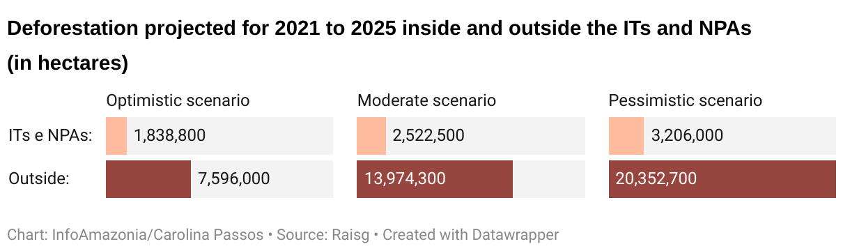
In the three projected scenarios developed by RAISG, less than 20% of total deforestation projected for the Amazon is located in the ITs and NPAs, demonstrating their importance as barriers to deforestation. Still, the scenarios show that these areas are increasingly vulnerable to what goes on in their vicinity and remain under constant strain.
Despite the drivers of deforestation presenting some common aspects in the Amazon region, each country has its own particular aspects and challenges to overcome.
En el mapa, pase el cursor sobre las áreas para ver más información acerca de la deforestación en cada país.
What Can be Done to Prevent the Worst
In order for the optimistic scenario envisaged by the RAISG study – in which deforestation is reduced by 10% in five years – to be possible, a series of environmentally-friendly actions must be implemented, such as the establishment of sustainable development plans, the management of protected areas, efficient public policies and better planning for road and population expansion, in addition to strengthening control and monitoring so that environmental regulations are enforced in all of the Amazon’s territory.
“It’s going to be very difficult to have an optimistic scenario if the main focus of local and national governments is on extractivist activities, whether they be oil, gas, hydrocarbons, minerals of different types, such as gold and coltan [from which niobium and the tantalum are extracted], and, of course, forest extraction in new areas rather than making use of the areas that have already been affected,” says Tina Oliveira-Miranda.
According to Pablo Moutinho, “the development of a truly Amazonian economy, a bioeconomy focused on zero deforestation, zero illegality and a sufficiently equitable distribution of income and land” is of the utmost importance.
According to the researcher, other essential measures consist in the continuing ratification and recognition of ITs, the creation of mechanisms to compensate for the environmental services provided particularly by the forest peoples and support for family agriculture, which includes technical assistance to put food on the table for the Amazon’s residents. He also cites the importance in planning the expansion of the road network.
“Infrastructure needs to fall under a larger plan for sustainable development. It is an entire set of zoning in function of this structure that allows you to have large pockets of forest conservation alongside the roads and regional economic activities in a narrower strip, closer to the main road,” Moutinho exemplifies.In the Brazilian Amazon, specialists highlight such important measures as designating the public forests for conservation or the sustainable use of resources, canceling fraudulent listings in the CAR [“Rural Environmental Registry”] – which are being declared in areas that overlap with public lands and even previously ratified ITs – as well as offering mechanisms of compensation for landowners who have a surplus of Legal Reserve .
Despite the bleak outlook, Tina Oliveira-Miranda believes that solutions for a more optimistic future can be found in the forest itself: “I believe that the Amazon Region is like a wonderful laboratory for changing practices and generating new models for development according to what we, as a human population, need to maintain our presence on the planet in a healthy manner.”
Sibélia Zanon
Reporter
Matthew Rinaldi
Translation to English
Carolina Passos
Data Visualization
Mathias Felipe
Development Manager
Xavier Bartaburu
Editor and coordinator
Juliana Mori
Direction
This feature was produced by InfoAmazonia in partnership with the Rede Amazônica de Informação Socioambiental Georreferenciada [“Amazon Network of Georeferenced Socio-Environmental Information“] (RAISG), with financial support from Good Energies.
Good work from the whole team, the information, writing, interactive website, all excellent. Regarding the information about the Amazon, it is a total shame that hundreds of unscrupulous people are taking the Amazon from us, unfortunate but we can all do something, stop buying pine wood furniture, Chihuguaco tree, exotic animals, denounce these activities, I don’t know what more could we do? … We who do not live in the Amazon need to know what we can do please.
You can only buy products that do not use deforestation to create them.