In MAAP #14 we take our first detailed look at the region of Cusco. The city of Cusco is of course well known as the former capital of the Inca empire and current gateway to Machu Picchu, but the greater Cusco region is a vast area including large tracts of Amazon forest. Here, we focus on the eastern Cusco region, an area that is experiencing increasing deforestation from gold mining and coca cultivation.
Key Results
We highlight two major expanding deforestation zones in the eastern Cusco region. Both zones are along major tributaries of the Araza River, which itself is a tributary of the Inambari River.
1) Nuciniscato River (see Zoom A). We documented a major deforestation spike since 2010 along this river and its major tributaries. Since 2010, there has been deforestation of 764 ha, much of which appears to be related to gold mining.
2) Nojonunta River (see Zoom B). We document a recent (2014) deforestation surge in this area, much of which appears to be related to coca cultivation.
Data Description
In the following maps:
Any variation of green in the satellite imagery indicates areas of forest cover.
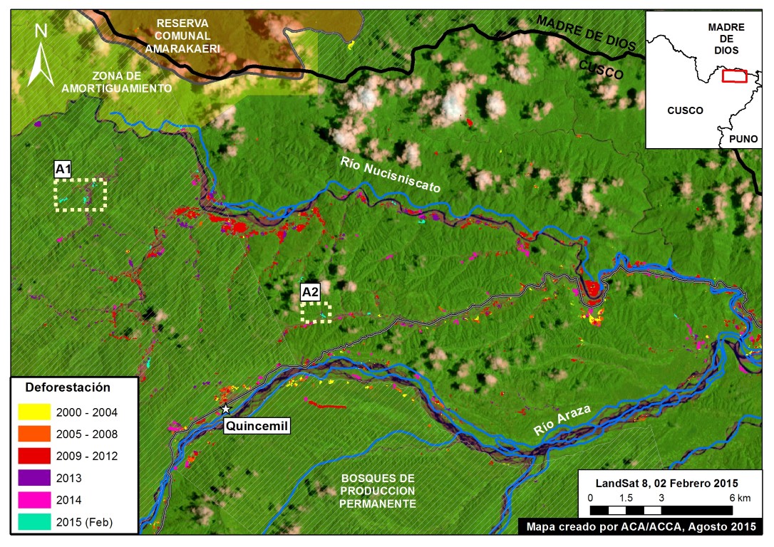
Yellow (2000-2004), orange (2005-2008), red (2009-2012), and purple (2013) indicate areas that were deforested between 2000 and 2013 according to data from the National Program of Forest Conservation for the Mitigation of Climate Change (PNCB) of the Ministry of the Environment of Peru.
The colors pink (2014) and turquoise (2015) indicate areas that were deforested in the last two years based on our analysis of Landsat imagery using CLASlite forest monitoring software.
Zoom A: Nuciniscato River
We documented the deforestation of 967 ha along the Nuciniscato River and its major tributaries since 2000. Image 14b shows that the vast majority (79% or 764 ha) of this deforestation has occurred since 2010. Peak deforestation occurred in 2012 (219 ha) and dipped slightly in 2014 (115 ha).
As noted in MAAP #6, part of this deforestation (along the upper Nuciniscato River) is entering the buffer zone of the Amarakaeri Communal Reserve.
Zooms A1 and A2: Examples of Deforestation in 2015
To better understand the principal deforestation drivers along the Nuciniscato River, we acquired high resolution satellite imagery. Much of the recent deforestation since 2010 is characteristic of gold mining: along river courses with forest clearing, earth removal, and waste-water lagoons. Images 14c and 14d both show very recent deforestation (between February and August 2015) with these characteristics.
Image 14c. Zoom A1 (see Image 14b for context). Data: SPOT 7 from Airbus, GeoEye from Digital Globe (NextView).
Image 14d. Zoom A2 (see Image 14b for context). Data: SPOT 7 from Airbus, GeoEye from Digital Globe (NextView).
Zoom B: Nojonunta River
We documented the deforestation of 477 ha along the Nojonunta River since 2000. Image 14e shows that the vast majority (85% or 403 ha) of this deforestation has occurred since 2010. Peak deforestation occurred in 2014 (207 ha), particularly in the upper Nojonunta.
Zoom B1: Deforestation Driven by Coca Cultivation
In the recent UNODC (United Nations Office on Drugs and Crime) report “Monitoreo de Cultivos de Coca 2014” [Coca Crop Monitoring 2014], it was reported that the area around the Nojonunta River (coca zone San Gabán) has a medium to high density of coca cultivation.
Image 14f displays the UNODC coca density data (left panel) in relation to a recent high resolution satellite image of the area (right panel). Thus, the data indicates that coca cultivation is a major driver of the deforestation detected in this case.
– This report was originally published in MAAP and is republished by an agreement to share content.


