• News
  • Maps
  • Projects
  • About us
    • Contact
Discovery
MORE
Dark mode
Type size
Follow us
  • Twitter
  • Instagram
  • Facebook
  • YouTube
  • Português
  • Spanish
  • English
Skip to content
What are you looking for?
  • Twitter
  • Instagram
  • Facebook
  • YouTube
  • PT
  • ES
  • EN
InfoAmazonia

InfoAmazonia

What are you looking for?
  • News
  • Maps
  • Projects
  • About us
    • Contact
Discovery

Página inicial » maps

Tag: maps

Is it possible to take care of the Amazon with the help of a computer?

By Giovanny Vera 13 de June de 201614 de September de 2020

From their computers, scientists and experts are translating technical data to allow us to see with new eyes what is happening with the Amazon.

Alarming growth areas of deforestation in the Amazon

By Annika McGinnis 18 de May de 201614 de September de 2020

Until 2015 were lost 158.658 hectares of forest in Peru, according to the map of deforestation of Global Land Analysis & Discovery alert system.

Large-scale vs. small-scale deforestation in the Peruvian Amazon

By Annika McGinnis 4 de May de 201614 de September de 2020

Previously we presented maps of deforestation hotspots in the Peruvian Amazon for the periods 2012-2014 and 2015, respectively. In this MAAP we present a complementary analysis based on the size of the deforestation events.

Gold mining ramps up, pushes deeper into Peruvian reserve

By Annika McGinnis 29 de April de 201614 de September de 2020

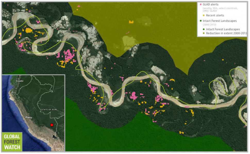
New data indicate a big surge in gold mining in and near Tambopata National Reserve over the past few months.

Infoamazonia is a finalist in the Garcia Marquez Prize

By Giovanny Vera 16 de November de 201314 de September de 2020

Project of interactive map of ((o))eco is among the first in the category innovation in award from Fundación Nuevo Periodismo.

What are the countries most affected by deforestation?

By Giovanny Vera 15 de November de 201314 de September de 2020

A new high-resolution map created with the help of Google Earth shows the current status of forests in the world.

Indigenous lands in Brazil seen from space

By Giovanny Vera 5 de August de 201314 de September de 2020

Meet some of the indigenous territories in Brazil and see interactive maps showing deforestation in these regions.

24% increase in Amazon deforestation

By Giovanny Vera 28 de June de 201314 de September de 2020

Terra-i data show a large increase in deforestation in the Amazon countries, excluding Brazil.

Relationship between roads and deforestation in the Amazon

By Giovanny Vera 17 de May de 201314 de September de 2020

Using data about the roads in Amazonia and information on deforestation rates, it is possible see the influence of infrastructure in the advancement of destruction.

Deter: data visualization, 2011

By Giovanny Vera 21 de February de 201214 de September de 2020

Data alerts deforestation in the Legal Amazon, 2011 can be viewed in graphical and interactive map. View ratings for municipalities and operational Ibama bases.

MOST READ

Large-scale vs. small-scale deforestation in the Peruvian Amazon

4 de May de 2016

What are the countries most affected by deforestation?

15 de November de 2013

Alarming growth areas of deforestation in the Amazon

18 de May de 2016

Is it possible to take care of the Amazon with the help of a computer?

13 de June de 2016

Gold mining ramps up, pushes deeper into Peruvian reserve

29 de April de 2016

  • Twitter
  • Instagram
  • Facebook
  • YouTube

CONTENT

  • News
  • Maps
  • Projects

INSTITUTIONAL

  • About us
  • Contact

OTHERS

  • Portuguese (Português)
  • Spanish (Español)

Web development by

Hacklab /