MAAP shows two additional types of satellites imagery (due to lack of new high-resolution image) indicating that the illegal gold mining deforestation continues to penetrate deeper into the Reserve.
Monitoring of the Andean Amazon Project
The Monitoring of the Andean Amazon Project (MAAP) is a web portal dedicated to presenting novel technical information and analysis pertaining to one of the most ecologically and socially important regions on the planet: the Andean Amazon (defined here as the sections of Bolivia, Colombia, Ecuador, and Peru within the Amazon watershed). The centerpiece of MAAP is the presentation of data and maps associated with a new near real-time deforestation monitoring system based on analysis of satellite imagery. O Projeto Monitoramento da Amazônia Andina (MAAP) é um site dedicado à apresentar novas informações técnicas e análises sobre uma das regiões mais importantes do mundo: a Amazônia Andina (aqui definida como seções da Bolívia, Colômbia, Equador e Peru na Bacia Amazônica). A peça central do MAAP é a apresentação de dados e mapas relacionados com um novo sistema de monitoramento do desmatamento em tempo quase real com base na análise de imagens de satélite. El Proyecto Monitoreo de la Amazonía Andina (MAAP) es un portal web dedicado a la presentación de información técnica novedosa y análisis sobre una de las regiones más importantes del planeta: la Amazonía Andina (definida aquí como las secciones de Bolivia, Colombia, Ecuador, y Perú dentro de la cuenca del Amazonas). La pieza central de MAAP es la presentación de datos y mapas relacionados con un nuevo sistema de monitoreo de la deforestación en tiempo casi real basado en el análisis de imágenes satelitales.
Increasing deforestation along lower Las Piedras River, Madre de Dios, Peru
The Las Piedras River, a major tributary of the Madre de Dios River in the southeast of the Peruvian Amazon, is increasingly being recognized for its exceptional wildlife, and by presence of indigenous peoples in voluntary isolation.
Yaguas – Another big conservation opportunity for Peru
In 2016, there is the opportunity for another major conservation victory in Peru: creation of Yaguas National Park. Yaguas received Reserved Zone status in 2011 and is now awaiting its final designation.
Deforestation by gold mining comes into Tambopata National Reserve, Peru
Satellite images show evidence of a recent invasion of the Tambopata National Reserve by gold mining activities.
Advancement of deforestation by gold mining in Alto Malinowski River, Peru
Map shows and confirms a high rate of deforestation by gold mining along the Alto Malinowski River, between September 2014 and November 2015, with loss of 392 hectares of forest.
Proliferation of logging roads in the Peruvian Amazon
Project shows high-resolution images of new forest roads that are built in the central Peruvian Amazon, in the regions of Loreto and Ucayali.
The birth of new area of illegal gold mining in Peru’s Amazon
New high resolution image of La Pampa of September 16, 2015 shows the birth of a new area of illegal gold mining, with a current area of 1.5 hectares.
Patterns and drivers of deforestation in the Peruvian Amazon
The report has identified three main drivers of deforestation in the Peruvian Amazon: large-scale plantations of oil palm and cocoa, gold mining and coca cultivation.
Sierra del Divisor: New logging road threatens Northern section of proposed Park
Here we show how the construction of a new logging road threatens the northwest section of the current Reserved Zone. New high-resolution images reveal that the construction of this logging road has continued to expand in 2015.
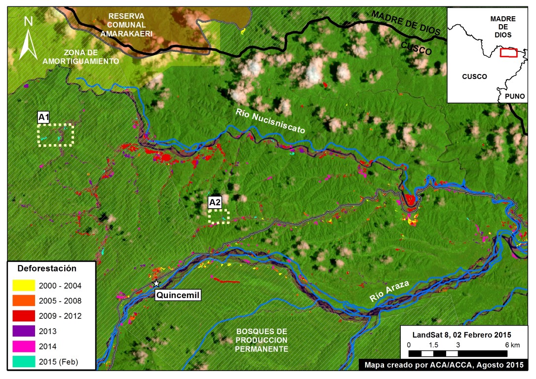
Cusco – Increasing deforestation driven by coca and gold mining
In MAAP #14 we take our first detailed look at the region of Cusco. The city of Cusco is of course well known as the former capital of the Inca empire and current gateway to Machu Picchu, but the greater Cusco region is a vast area including large tracts of Amazon forest. Here, we focus […]
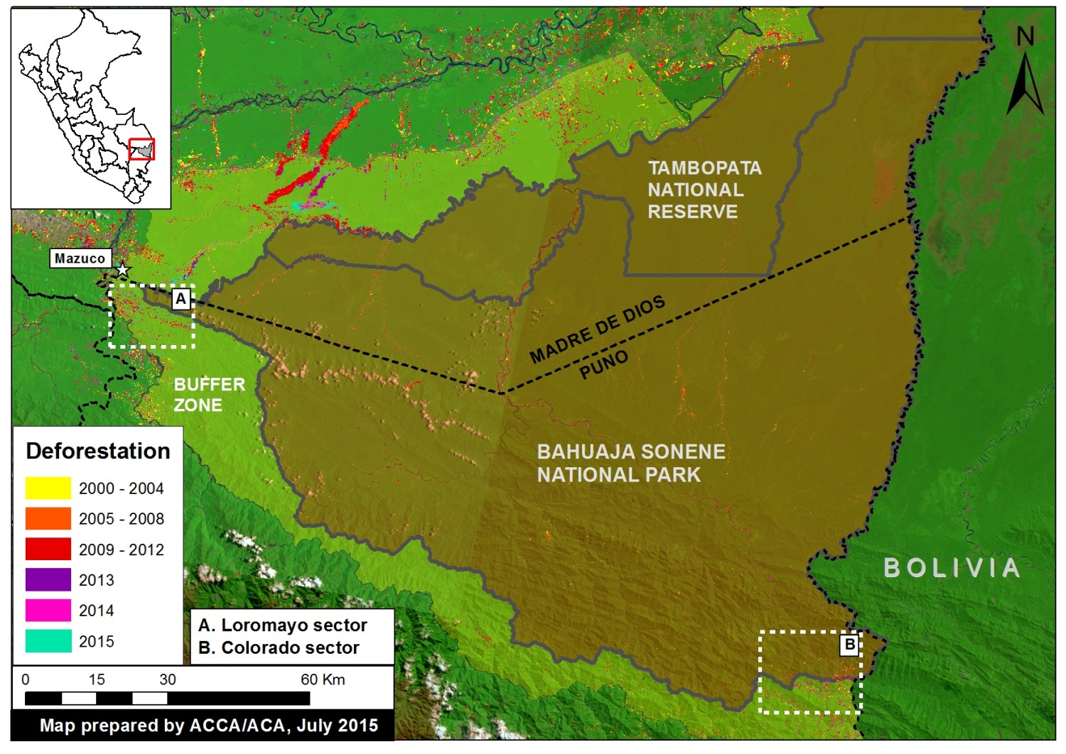