Prodes data are ready since October 27 but were only released this Wednesday. This rate is almost 22% higher than 2020, a record year. Amazonas jumps to second place in state-wide rankings.
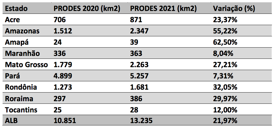
The Legal Amazon lost 13,235 km² of forest between August 2020 and July this year. The area is equivalent to eight times that of the city of São Paulo. Losses are 21.97% higher compared to the 10,851 km² deforested in 2020, which was already a 12-year record. This is the third consecutive increase in deforestation in the three years of the Jair Bolsonaro government, and the highest rate since 2006, when 14,286 km² were cut down.
The data are an estimate of the deforestation rate by INPE’s Legal Amazon Deforestation Satellite Monitoring Project (Prodes), linked to the federal government, released this Thursday, 18th, without fanfare.
According to reports from the Climate Observatory and MapBiomas, the deforested area of 13,235 km² represents a 75% increase in forest losses since 2018. In the three years since the current administration took power, accumulated deforestation reaches 34,215 km². The amount represents 1.9 billion trees felled according to data from the PlenaMata monitor, as well as 2 billion tons of CO₂ released into the atmosphere, boosting global warming. Deforestation grew in all the states of the North Region, especially in Pará, Amazonas, and Mato Grosso, a first since 1998.
“The (PRODES) result stems from persistent, planned, and continuous efforts to destroy the environmental protection policies under the Jair Bolsonaro regime. It is the triumph of a cruel project that makes the world’s largest rainforest disappear before our eyes and makes Bolsonaro’s Brazil a global climate threat”, said Marcio Astrini, executive secretary of the Climate Observatory.
PlenaMata platform monitor map shows the annual deforestation rate from 1998 to 2021 (yellow to red). Zoom in to see details of deforested areas.
The result stems from persistent, planned, and continuous efforts to destroy the environmental protection policies under the Jair Bolsonaro regime. It is the triumph of a cruel project that makes the world’s largest rainforest disappear before our eyes and makes Bolsonaro’s Brazil a global climate threat.
Marcio Astrini, executive secretary of the Climate Observatory
The deforestation rate was disclosed discreetly this Thursday (18th) on the INPE website, linked to the Ministry of Science, Technology, and Innovation. The report is dated October 27th, which shows that the government already knew about the increase in deforestation three days before the start of the 26th United Nations Conference on Climate Change, COP26, on October 31st, where they are usually disclosed.
João Paulo Capobianco, from Coalizão Brasil Clima, Forests, and Agriculture, says Brazil is witnessing a “double scandal”. “The first is the fact that the note released by Inpe predates the Climate Conference. This is the first time that Prodes was not released before or during the COP. The federal government went to Glasgow already aware of the deforestation rate but chose to speak about another metric, Deter, which pointed to a slight reduction instead.
“Another shocking factor is the sheer increase in deforestation, which occurred despite years of massive investment in the presence of the Armed Forces in the Amazon. It only proves everyone what everyone who followed the environmental agenda knew: deforestation is fought with planning and interventions in strategically defined areas, and not by the mere movement of thousands of soldiers, without internal planning, to an area of continental dimensions. If there is no radical change in approach, this advance in deforestation could become exponential,” summed up the ex-coordinator of the Amazon Deforestation Prevention and Control Plan (PPCDAm).
Official data show that deforestation has soared in the states that are historically the worst offenders in the Legal Amazon, such as Pará (39.72%) and Mato Grosso (17.10%). The novelty was that Amazonas now placed second, with 17.73% of total losses according to INPE. Compared to last year, deforestation in the state grew by 55%. The percentage increase was only greater in Amapá, at 62.5%.

Along with Acre and Rondônia, Amazonas is home to the Abuna-Madeira Sustainable Development Zone. A report by InfoAmazonia revealed that this new agricultural hub, which has the support of the Bolsonaro administration and state governors, has become the new epicenter for deforestation in the Amazon.
Amazonas is the second most deforested state in the Amazon, with 17.73% of forest losses recorded by INPE, an increase of 55%.
The disclosed figures are estimates which will be consolidated in the first half of 2022. However, these deforestation estimates are usually confirmed by the government agency.
Prodes mapping is based on Landsat satellite images and keeps the record of deforested areas larger than 6.25 hectares. The system considers deforestation to be the complete removal of primary forest cover by clear cutting, regardless of the future use of these areas. The estimate of the 2021 rate was calculated based on the analysis of 106 priority scenes from all states in the Legal Amazon.
Story by InfoAmazonia for the PlenaMata project.


This is truly alarming news. The fact that deforestation in the Amazon has increased by 22% in 2021 is not just a statistic; it’s a dire warning about the future of our planet. The Amazon rainforest is a critical part of the Earth’s ecosystem, playing a vital role in regulating the climate and supporting biodiversity. If we don’t take urgent action to protect it, we risk losing an irreplaceable natural resource. It’s crucial for governments, organizations, and individuals to work together to halt deforestation and invest in sustainable solutions to preserve this invaluable rainforest for future generations.