
Water and Citizenship go hand in hand. When sources of clean water are damaged, human health suffers along with the social and economic health of communities that depend on agriculture and fishing, among other activities.
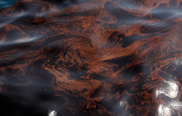
Oil spilled in the month of July in the Marañon River, in Loreto department, Peru. Leaks are on the rise in this region of the Amazon. Photo: Actualidad Ambiental
In the Amazon, as we know, water isn’t lacking. However, the management of the water resources in the region, many times dissociated from social participation, threatenes the source of survival for its residents besides dozens of animal and vegetable species.
The examples of the impacts of pollution by sewage, oil spills, infrastructure works, overfishing and others are growing throughout the Amazon.
In 2014, InfoAmazonia undertook the challenge of including the citizen report
as a layer of information on maps of deforestation, mining, oil and others that were created in the past two years. For that reason, today we launch the first version of our web application for collecting reports and community sotries with a focus on the water question.
InfoAmazonia Citizen – Water is an effort in partnership with NGOs in Brazil, Bolivia and Peru to map the principal degradation problems of rivers and lakes in the Amazon Basin. We are also colecting information about projects that conserve springs and sub-basins.
All of the aggregated information in InfoAmazonia Citizen will be available for download. The reports and the map will be embeddable for other web pages with the embed code
Here we include the report about the oil spill which occured in July in the Peruvian Amazon:
Open Data: the river map
To map the water issue in the Amazon, the InfoAmazonia team also analized a serious of databases about the Amazon basin and its sub-basins. The idea is to provide a map sufficiently detailed so that the citizen reports can be localized in specific places along a river or stream.
What we found was that, although there is detailed data available, it does not always posses an open license. Below you can see a brief description of the databases.
1. Our ochoise was to create the base of the “Water” application using the data from Open Street Map. The data is still not ideal, but it is in constant revisal and the license for use allows the creation of derived products.
2. Drainage areas – data from IBGE-Brasil. As you can see there is an enormous quantity of details and the base of the map is hardly visible. The file is available for download, but the use for the creation of new products or applications must be authorized by communicating with IBGE.
3. Finally, we also looked at data from the Hydrosheds project, a product of the partnership between WWF and the United States Geological Service (USGS). Like the IBGE data, there is great detail, although the names of the rivers are not available in the shapefile (SHP). The data is available for download, but only for research purposes, with other possible uses only allowed upon authorization. Here is the link to download the data
